
קובץ:Via Flaminia map.jpg
גודל התצוגה המקדימה הזאת: 600 × 600 פיקסלים. רזולוציות אחרות: 240 × 240 פיקסלים | 480 × 480 פיקסלים | 1,000 × 1,000 פיקסלים.
לקובץ המקורי (1,000 × 1,000 פיקסלים, גודל הקובץ: 635 ק"ב, סוג MIME: image/jpeg)
| זהו קובץ שמקורו במיזם ויקישיתוף. תיאורו בדף תיאור הקובץ המקורי (בעברית) מוצג למטה. |
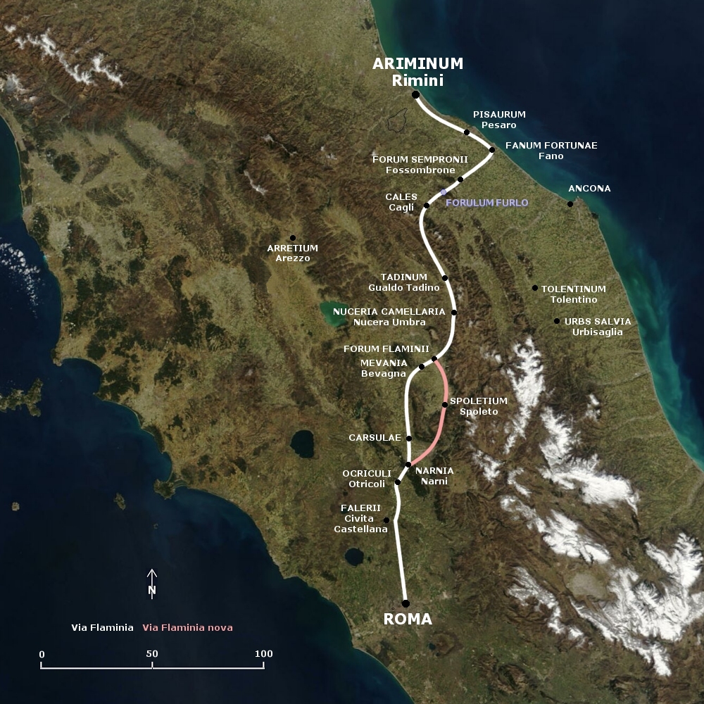
English: Map of the Via Flaminia and the later Via Flaminia Nova.
Deutsch: Karte der Via Flaminia und der Via Flaminia Nova.
תקציר
This map is based on the following picture: Image:Satellite image of Italy in March 2003.jpg
רישיון
| ברצוני, בעלי זכויות היוצרים על יצירה זו, לשחרר יצירה זו לנחלת הכלל. זה תקף בכל העולם. יש מדינות שבהן הדבר אינו אפשרי על פי חוק, אם כך: אני מעניק לכל אחד את הזכות להשתמש בעבודה זו לכל מטרה שהיא, ללא תנאים כלשהם, אלא אם כן תנאים כאלה נדרשים על פי חוק. |
| קובץ זה נמצא ברשות הציבור מכיוון שהוא נוצר על ידי נאס"א. מדיניות זכויות היוצרים של נאס"א קובעת ש"חומרים של NASA אינם מוגנים בזכויות יוצרים אלא אם צוין אחרת". (דף מדיניות זכויות היוצרים ב-NASA או מדיניות שימוש בתמונות ב-JPL). | ||
 |
אזהרות:
|
היסטוריית הקובץ
ניתן ללחוץ על תאריך/שעה כדי לראות את הקובץ כפי שנראה באותו זמן.
| תאריך/שעה | תמונה ממוזערת | ממדים | משתמש | הערה | |
|---|---|---|---|---|---|
| נוכחית | 19:33, 7 באפריל 2008 | | 1,000 × 1,000 (635 ק"ב) | AlMare | corrected: Ariminum, -Perusia, +Arretium |
| 03:34, 7 בנובמבר 2006 |  | 1,000 × 1,000 (569 ק"ב) | AlMare | {{en|Map of the Via Flaminia and the later Via Flaminia Nova.}} {{de|Karte der Via Flaminia und der Via Flaminia Nova.}} == Summary == This map is based on the following picture: [[:Image:Satellite image of Italy | |
| 03:25, 7 בנובמבר 2006 |  | 1,000 × 1,000 (569 ק"ב) | AlMare | {{en|Map of the Via Flaminia and the later Via Flaminia Nova.}} {{de|Karte der Via Flaminia und der Via Flaminia Nova.}} == Summary == This map is based on the following picture: [[:Image:Satellite image of Italy |
שימוש בקובץ
הדף הבא משתמש בקובץ הזה:
שימוש גלובלי בקובץ
אתרי הוויקי השונים הבאים משתמשים בקובץ זה:
- שימוש באתר be.wikipedia.org
- שימוש באתר de.wikipedia.org
- שימוש באתר hu.wikipedia.org
- שימוש באתר pl.wikipedia.org
- שימוש באתר ru.wikipedia.org
- שימוש באתר sk.wikipedia.org